Search This Blog

Showing posts with label US Army Corps of Engineers. Show all posts

Monday, February 28, 2022

"The Big Sandy" by Carol Crowe-Carraco--Book Review

 This book is a bit dated and only covers the history of the Big Sandy River Basin from about 1675 to 1978, about a year before the publication date in 1979.  The book was one of about two dozen books published by The University Press of Kentucky in order to offer wider documentation of Kentucky history.  The author, Carol Crowe-Carraco, was a distinguished professor of history at Western Kentucky University and has an impressive list of publications in the field of Kentucky History. The book is well reserched and has a very useful six pages of notes which, while they do not comprise a true bibliography, can be utilized as such.  The book also lacks an index which would be very useful to the average reader.  

I read the book as a part of a much more sizeable project in which I am currently involved about the Big Sandy River Basin and its place in American History.  While I am certain this will not prove to be the best or most important book I read as a part of this project, it has been useful and I can recommend it to the average reader who is interested in the history of either the Big Sandy River Basin in particular or Kentucky History in general. For my purposes, the book was particularly informative about the history of the river with regard to navigation, the involvement of the U. S. Army Corps of Engineers in the history of the river, and the history of early steamboat usage on the river prior to the coming of the railroads.  As a person who grew up in the headwaters of the Big Sandy on Right Beaver Creek in Knott County and walked to and from grade school for 7 years along the railroad of the C & O, it was particularly interesting in its discussion of the building of the railroads.  The book also can be informative for the average reader in the area of the coming of the coal camp towns in the river basin.  But as one who has spent his life living and working in the region and also studied coal camp towns extensively, the book did not offer anything new to me in that area.  For the average student of the coal camp towns, it would be worth reading.  

Professor Crowe-Carraco writes well in a professional matter but her prose is not the kind that leaves a reader awestruck.  It is geared more toward students of history who often prefer more staid, dry fact statements than any form of flowery literature.  That is not a fault in this type of book.  I simply offer it as a way for anyone considering buying and reading the book to determine if they are likely to enjoy it.  The bottom line of the entire impression the book made on me is that, even with its one or two minor faults from my point of view, it is a book worth the time and money to spend on it.  It has legitimately piqued my interest in reading more of the Kentucky Bicentennial Bookshelf publications.  It might do the same for you.    

Monday, August 2, 2021

Hiking At Paintsville Lake State Park!


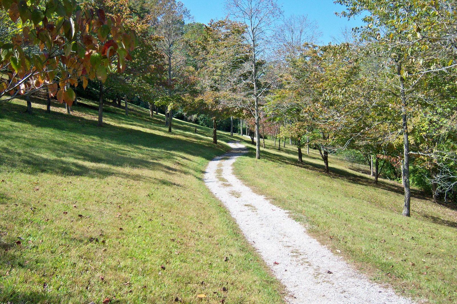
The photo above is a stock photo of the prettiest portion of what is known as the Kiwanis Hiking Trail at Paintsville Lake State Park which is a trail I hike regularly and just hiked today, in fact.  The trail actually begins near the Kentucky Mountain Homeplace which is also well worth a visit.  You can park in their parking lot, and out of courtesy, as far from their headquarters building as possible and start your hike at either end of the trail which makes a loop around the Army Corps of Engineers headquarters and the Kentucky Mountain Homeplace.  The trail has a couple of slight uphills or downhills but is actually rated, in my mind, as easy.  The section in the photo is just east of and below the Corps of Engineers headquarters and a few hundred yards from the beginning on the highway near KMH.  Paintsville Lake and the marina area are below the trail at this point and just east of it.  A small section of the lake is visible from the trail along with part of the marina area.  Then the trail goes away from the lake, crosses the emergency spillway (or gives you the option of shortening your hike a little by taking the emergency spillway until you rejoin the loop of the main trail near the SW corner of the KMH property.  I actually took that option today although I usually hike the entire loop of the trail with an extra twist or two thrown in.  The main loop is more tree shaded, feels a bit more isolated, and has a generally prettier look than the emergency spillway which is actually a cut through in the hillside which leaves a flat grassy area maybe 100 yards wide which functions as the emergency spillway.  

When I say that I throw in an extra twist or two to my hikes here,  what I mean is that I usually park at the spillway near the public restrooms and public trout stocking area, maybe take one full loop around the spillway area and then hit the face of the dam, go straight up the dam to the highway which crosses there to access the Corps of Engineers office and KMH.  I hike straight up several of the flood control lake dams in Eastern Kentucky and I recommend it if you are a strong hiker with a good heart and lungs, strong legs, and a good back.  But all these dams are steep, high, and tough.  The Paintsville dam is especially tough since it has a large area of boulders about 100 feet from bottom to top all across the dam due most probably to some past seepage problem.  Do not attempt this dam unless you are pretty tough and nimble.  The second twist I throw in my hikes here is that when I have hiked about 90% of the entire loop and I am back in the area overlooking the spillway where I park,  I hit the woods downhill toward the spillway.  It is typical Eastern Kentucky woodland, steep, and rocky.  It also has a couple of places where you could fall 30 feet or so.  But in this area, there is an ancient rock shelter, not a cave, but a rock shelter, overhang, whatever you want to call it which I am sure was used historically by both early native peoples and some of the first settlers in the Paint Creek area as temporary shelter.  It would sleep about a half dozen people and IT IS NOT LEGAL TO CAMP IN IT but it is a nice spot to stop for a few minutes at the end of a hike, cool off, and consider how it might have been used historically.  Paintsville Lake and the Kiwanis Trail is a nice hike whether you are looking for a relatively easy loop or if you want to make the loop more difficult as I do.

Thursday, August 29, 2019

Hiking At The Twenty-Six Boat Ramp, Daniel Boone National Forest--August 29, 2019

Today, August 29, 2019, my wife Candice and I took a long drive in the country and I took two side trips to hike in the Daniel Boone National Forest and/or Cave Run Lake.  First I spent a half hour or so at the Twenty-Six Boat Ramp which is located just off Kentucky 772 about a mile or less from Kentucky 519 just about a mile from the Morgan/Rowan County Line in Morgan County.  Even though I have lived in the area for more than twenty-five years, I had never been to the boat ramp area in question.  I had actually arrived there by the long way around through the Kentucky State Tree Nursery and Woodsbend Youth Development Center in the Woodsbend area on Lower Grassy Creek.  It is a beautiful drive along that route through some of the best farm land in all of Morgan County.  There are numerous well maintained farms, the Tree Nursery and the Youth Development Center as well as three major, well maintained and photogenic cemeteries along the way.  The most interesting of those cemeteries is the Bear Wallow Cemetery. With a name like that, how could you avoid taking a drive along this wonderful scenic route?  

But once you arrive at the Twenty-Six Boat Ramp, a great deal of the beauty is lost due to abuses of the site by what seems to be a group of partiers from time to time combined with an overloaded Corps of Engineers who probably do not have the time or staff to adequately maintain all the public use facilities in the Daniel Boone National Forest.  The drive off Kentucky 772 to the boat ramp is tree shaded, scenic, and inviting.  It has a large gravel parking area, a concrete boat ramp, and lies on a tributary of Cave Run Lake.  All of this should have combined to make a wonderful location to hike, fish, kayak, launch boats, and simply eat a leisurely lunch on a work day.  But the ramp was poorly situated and is pointed upstream which means that a lot of debris ends up in the ramp launching area and at least one large log was visible in the water on one side of the ramp directly in front of the incoming boats which I suspect are few and far between since a far better situated and maintained ramp is located only a couple of miles away just across the line in Rowan County.  Between the parking lot and the water, there is an area which is about four feet lower than the parking lot and probably two feet above the normal water line.  But it is subject to periodic flooding when the Corps of Engineers is holding large amounts of water in the lake.  The normal amount of debris which would end up in area like that would be expected and workable.  But the people who have been using and abusing the boat ramp area have made a workable situation both disgusting and infuriating.  I hiked this area for quite some distance downstream along the waterside and found it littered from one end to the other with all sorts of garbage.  I usually carry a plastic grocery bag with me when I hike and pick up whatever litter I find in the locations I utilize no matter where they are, whether I have ever been there or not, and whether or not I ever likely to return.  But if I had the assistance and time today, I and a couple of friends could have easily filled the bed of my Ford Ranger with garbage which had been thrown about by the users of the area.  I actually found the remains of several camp fires and two them had the remnants of automobile tires in the ashes.  One had the steel belt wires from a large tire combined with beer and soft drink bottles, Styrofoam live bait containers, and general garbage.  And this particular camp fire was not the worst of the lot.  Another had not only the steel belt wires from a tire combined with its bushel of garbage.  It also had the steel rim from a large automobile tire.  In addition to these camp fires, the entire area was randomly littered with what were obviously fresh bottles and cans which showed no evidence of ever having floated in on the waters.  This entire area is a disgrace to every human who has ever helped to damage it.  

This area is tree shaded, quiet, inviting, and on the edge of the water.  It could be a wonderful site to use in a variety of ways.  But in its current condition, I am certain that it drives potential users away on a regular basis.  It is in dire need of a major clean up and regular policing from the Corps of Engineers and local law enforcement and yet I know that all these agencies are understaffed and overloaded.  The bottom line is that it is a damn shame and in desperate need of change on a major level. 

****************************************************************************
After I left the Twenty-Six Boat Ramp area, I crossed the county line into Rowan County and turned right up the first paved road into an area which is part of the upstream lake and is used as a camping and hiking site.  I do not recall the particular name or number which is assigned to this road but it is the last left turn off Kentucky 519 in Rowan County before the bridge at the Morgan County line.  At about a half mile, you find several camp sites with rudimentary launching for small boats.  Then there is a locked gate across the road which is obviously the old state highway along the Licking River before it became a part of the lake.  The road is only a couple of feet above the water line and still in acceptable condition.  There area a plethora of spots along this road which could be used as lake shore fishing spots.  It is quiet, tree shaded, flat at least on the area I hiked, and a wonderful place to hike, fish, ride a bike, etc.  It is closed to vehicular traffic beyond the aforementioned gate. During my hike, I encountered a nice lady who was riding a vintage bicycle along the road and camping with her family at one of the camp sites.  She advised me that the road extends for roughly five miles or more along the lake shore and connects with another old road which climbs the mountain side to cross out of the Daniel Boone National Forest.  She also told me of a rumor that is rampant among users of the area that the Corps of Engineers is planning to lease that area to a vendor who is already renting kayaks on the lake for use as a paid camping, hiking, and multi-use area.  I tend to doubt the rumor but I will admit that it could be possible.  I hope to return to this area and spend more time and distance hiking it to see as much of it as I can.  When I do, of course, I will post about it on this blog.  

These two areas which I hiked today are well worth the time to utilize if you are in the general area.  I would also encourage all of you to contact the Army Corps of Engineers Office in Morehead and discuss the need to clean up and enforce civilized practises on the users of the Twenty-Six Boat Ramp.  If you utilize it, please take a camera along, which I did not do today, and shoot some photos of the egregious garbage, campfires with evidence of burnt tires, and pass them along to the Corps of Engineers. 

Sunday, January 13, 2013

Relocated Cemeteries In Appalachia

A recent posting by my blogging friend the Wayfarin' Stranger on his blog which was actually about an old one room school prompted this post. The post and his wonderful blog can be found at: http://cumberlandvistas.blogspot.com/2012/05/one-room-school.html  I responded to his discussion of the movement of the school for the creation of Cave Run Lake near his native Morehead, KY,  with an e-mail about the need for both of us to examine and blog about the movement of family cemeteries to facilitate the construction of these flood control projects all over Appalachia.  He responded with the idea that we both write about it and cross link our articles which was his way to get me reactivated in blogging since I had done nothing since the March 2, 2011, tornado devastated my home town of West Liberty, KY.  That is a topic which I will approach sometime soon.  It is still a bit too fresh in most of our minds.

But, to get back to the real topic of this article, there are several federally funded flood control lakes in every state in the Central Appalachian Region.  Within easy driving distance of me, there are Cave Run Lake, Paintsville Lake, Yatesville Lake, Dewey Lake, and Buckhorn Lake.  All were built after World War II, funded by federal dollars, and in whole or in part managed by the US Army Corps of Engineers.  There are actually 18 such lakes in the entire state of Kentucky, 10 throughout West Virginia, 5 in Tennessee, 6 in Virginia, 4 in North Carolina, and 10 in Georgia.  Each of these states may also have one or more river drainages which are overseen by the Corps of Engineers.  There are also several other lakes in each of the states which is partially contained in the greater Appalachian area but outside Central or Southern Appalachia.  I am concerned only with the cemeteries which have been affected by the construction of lakes in the Central Appalachian Region.  But within the states named, there are more than 50 such lakes. I also note for the record that all of the above states territory does not lie in Central Appalachia and neither do all of the 53 lakes. 

The Corps of Engineers actually controls more than 400 lakes in 43 states.  Nearly every one of these man made lakes required the movement of grave sites and cemeteries.  A few may have also affected or destroyed Native American archaeological sites including grave sites. A fairly good, but relatively non-disclosive and primarily tourism oriented page about the lakes can be found at:  http://corpslakes.usace.army.mil/visitors/visitors.cfm

Each of these lakes is entirely man made and their construction mandated the removal and relocation of several and perhaps dozens of small, family cemeteries.  In each case, the government purchased title to the land involved whenever possible and paid contractors to excavate and relocate all known graves which would be in the flood plain of the lakes. Whenever opposition to the individual purchases was encountered, the government began adverse legal proceedings under the legal doctrine known as eminent domain and seized the land.  In either case, the government paid for the purchase of land near the lake for the construction of a merged cemetery which would contain most or all of the relocated graves.  So far as I know, in each case, the cemeteries were also built large enough to allow for the burial of future dead in the locale.  Whenever descendants objected to relocation of graves to the merged cemetery, they were generally given the option of moving them to a site of their own choosing although this relocation may not have been at government expense. And one of the other real tragedies of this whole relocation effort lies in the fact that many of the older cemeteries would have also contained poorly marked or even totally unmarked graves which were never found and are flooded today.  In many of these cases, no living human remained who even remembered the exact location of these graves or the names of the individuals buried in them. 

Each of these merged cemeteries is operated by a manager under the laws of the state and federal governments. Most, if not all, of these cemeteries are managed in an efficient and ethical fashion.  This article is intended to be a non-biased look at the cultural issues involved in relocation of graves in Appalachia and not intended as any negative assessment of the processes involved in the management of the new cemeteries.  I will leave readers to draw their own conclusions about how this massive relocation of graves has affected the descendants of the dead in each case, both in and outside Central Appalachia. 

I have not visited most of the cemeteries involved in Central Appalachia.  But I have visited several in both Kentucky and West Virginia.  I am more concerned with the general cultural issues involved and limit specific references to those lakes and cemeteries with which I am most familiar.  I have also sought to gain first hand information from one or more of the managers involved in the process.  However, an initial attempt to gain previously publicly released information about the cemeteries from a Corps of Engineers employee was less than openly addressed.  I suspect that, in many cases, relocation of graves has been a touchy subject in Central Appalachia.  I can only vaguely remember the construction of Carr Fork Lake in my native Knott County Kentucky.  But I do recall that my neighbors who were often unemployed avoided applying for the jobs available as laborers in the relocation process.  Contractors were generally not local but did advertise and hire local people when they would accept the work.    However, most local males would not apply for and would not have accepted jobs whose sole purpose was the excavation of graves and relocation of the dead.

Culturally speaking, three major aspects and key values of Appalachian Culture collide with the process of relocating cemeteries. These values are Love of Place, Familism, and Religion.  These relocated graves and cemeteries were most often located on old family home places and considered sacred to the descendants.  The two most important institutions in Appalachian Culture are family and church.  The three most important physical locations to the average Appalachian are the old home place, the family cemetery, and the church which the family usually attended.  In many cases, the construction of these lakes and the relocation of graves would have destroyed all three of these important locations and dealt serious damage to the two institutions as well. In all cases of property transfers for these lakes, the property would have been appraised at actual market value if sold.  Many of these older churches, especially Old Regular Baptist, United Baptist, Holiness, and Pentecostal churches would have been simple wood frame buildings with little monetary value in relation to their religious and cultural value. These congregations would have often been tasked with buying land and building new buildings in an area where land was now more valuable both because of the tourism potential and the increased scarcity due to flooding. More often than not, these small congregations would have been placed in a position of great monetary stress due to the much larger cost of replacement compared to the market value of buildings that were small, cheaply built, and of advanced age.

Although I do not generally believe that feuding was as common an occurrence in Appalachia as various forms of media have described it, disagreements between neighboring families occur in all locales across the world as a part of normal daily life.  Relocating several small family cemeteries in a relatively constricted locale, usually one creek or river valley, would have often resulted in members of several families being buried in close proximity to people with whom they had disagreed in life.  Descendants would not have forgotten those disagreements and would have been upset by the idea of having family members buried in the same cemetery with "them Hicks'" for example. 


But the real opposition to moving graves lay in the idea that graves are sacred and the dead should remain in the original grave until the resurrection. This is a topic which I did not address adequately in my earlier posting about family cemeteries.  It was an idea I should have addressed more thoroughly at the time.  Most graves in Appalachia, especially if they are more than 40 or 50 years old, nearly always face the rising sun due to the belief that the resurrection will happen in the early morning at or near sunrise.  This positioning of the graves is intended to guarantee that the people interred will be oriented toward the coming Jesus in order to be one of the first to rise from the grave. The relocated cemeteries almost never made a point of facing graves toward the rising sun and usually located the orientation in the manner most likely to maximize the use of the land.  This point alone would be upsetting to descendants of the dead who had been raised to practice this religious based custom. 

Whenever I discuss the issues of death and burial in Appalachia, I generally refer to two books: "Death And Dying In Central Appalachia" by James K. Crissman and "Coal Camp Kids" by Barbara Ford Ritch.  "Faith And Meaning In The Southern Uplands" by Loyal Jones, whose work I often mention, also contains material pertinent to this discussion. The Crissman book is a somewhat dated but classic discussion of nearly every aspect of death and dying in Appalachia. It is in every way a masterpiece.  The Ritch book is a large oral history of the coal camps on Beaver Creek in Floyd County Kentucky which contains a large chapter on death, dying, and burial customs which contains many vintage photographs of graves, tomb stones, caskets, and dead bodies.  It is somewhat deficient in expository writing but the photos and first person transcriptions are quite informative.  For those readers who are interested in further information on the topic of death in Appalachia, I would also refer you to any or all available copies of "The Minutes" of any of the various associations of the Old Regular Baptist Church in Kentucky, Virginia, West Virginia, Tennessee, and several of the northern states affected by the Great Migration.  Individual obituaries are generally contained in most associations minutes and are written by either ministers or family members who knew the deceased individuals.  Although they may appear to follow a stock and rather staid format, individual obituaries may contain real gems of cultural information and these gems may often be found only by browsing dozens of "Minutes".  I refer to one such obituary in my post on "Visiting The Urban Appalachians In Kendallville Indiana".  Although I have never done research there, it is my understanding that the University of Pikeville library in Pikeville Kentucky has a nearly complete collection of these minutes from several of the associations.  Each of these "Minutes" is an annual report of events in a particular association of Old Regular Baptist Churches and, in addition to the obituaries, contains statistical reports of the churches.  They are a wealth of information for researchers and the simply curious in Appalachia.  In particular, the statistics are often far more complete than other enumerations of any kind at the same time in Appalachia. 

There have also been numerous cultural collisions between coal and other mineral extraction companies and the local populace concerning attempts to relocate cemeteries in order to facilitate strip mines, oil wells, gas wells, and rock quarries.  One such battle is currently ongoing at Carcassone in Letcher County Kentucky.  I have no direct personal knowledge of the conflict other than what I have seen in the media. But a local couple whose family members are buried on a small, mountaintop cemetery are involved in an ongoing battle with a coal company which wants to move the cemetery more than twenty miles away, which is a massive distance by Appalachian mountain standards.  Newspaper accounts can be found at the Mountain Eagle , the local newspaper in Whitesburg, KY. I will attempt to directly contact the people involved in the conflict and gain more information which is certainly pertinent to this discussion.

 
This article will not be complete until I have managed to interview at least a couple of the cemetery managers involved about policies and procedures involved in the relocation of these graves.  I will also try to take the time to do some research in the Floyd, Rowan, and Johnson County Kentucky Libraries and newspaper morgues from the time period involved in the construction of Dewey Lake and Paintsville Lake in order to search for information about current events and opinions at the time the lakes were created.  Please feel free to insert your own personal information about this process and to make suggestions of ways to obtain more accurate information about the processes involved.  I would also love to interview any former employees who may have worked in the relocations.